
Save weeks of setup time with this professionally crafted, province-wide Alberta mapping solution. Designed for surveyors, engineers, planners, and CAD professionals, this complete set includes 50 stitchable AutoCAD drawings covering the full province of Alberta.
Each tile is meticulously built to the Alberta Township System (ATS), including:
Roads, hamlets, towns, cities, reservations and parks
Sections, townships, and ranges
Cutlines and waterbodies
Consistent layers and alignment for seamless stitching
Key Features:
Ready-to-use in AutoCAD – drop the files into your projects and start working immediately
Province-wide coverage – modular tiles that can be combined into one full map
Professional layer structure – organized for efficiency and clarity
High accuracy – reliable for engineering, planning, and land use projects
Time-saving – eliminates hours of manual drafting, letting you focus on your projects
Geo-referenced:
All W5 & W6 ATS drawings are geo-referenced to UTM NAD83 Zone 11
All W4 ATS drawings are geo-referenced to UTM NAD83 Zone 12
Metric units – all drawings are created in metric units
Bonus:
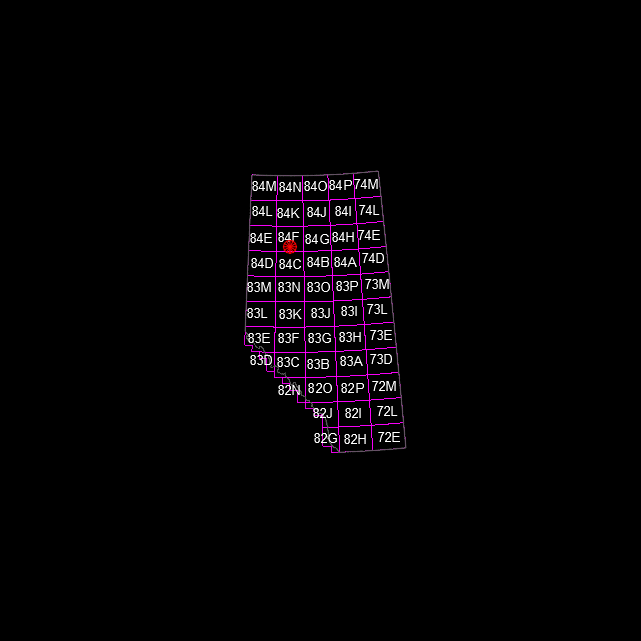
Includes a reference PDF showing the tile index map
Includes a PDF showing Stitching instructions
Who This Is For:
Surveyors and engineers working in Alberta
Planners, developers, and infrastructure teams
CAD professionals who need ready-made, accurate base maps
This is a premium, time-saving tool. Creating these maps from scratch could take days or weeks. With this set, you get a full-province, professional-grade CAD resource ready to integrate into your workflow.
Delivery:
Due to file size, downloads are provided via a secure access file containing links to two ZIP files, organized by UTM zone, and two PDF files.
Save weeks of setup time with this professionally crafted, province-wide Alberta mapping solution. Designed for surveyors, engineers, planners, and CAD professionals, this complete set includes 50 stitchable AutoCAD drawings covering the full province of Alberta.
Each tile is meticulously built to the Alberta Township System (ATS), including:
Roads, hamlets, towns, cities, reservations and parks
Sections, townships, and ranges
Cutlines and waterbodies
Consistent layers and alignment for seamless stitching
Key Features:
Ready-to-use in AutoCAD – drop the files into your projects and start working immediately
Province-wide coverage – modular tiles that can be combined into one full map
Professional layer structure – organized for efficiency and clarity
High accuracy – reliable for engineering, planning, and land use projects
Time-saving – eliminates hours of manual drafting, letting you focus on your projects
Geo-referenced:
All W5 & W6 ATS drawings are geo-referenced to UTM NAD83 Zone 11
All W4 ATS drawings are geo-referenced to UTM NAD83 Zone 12
Metric units – all drawings are created in metric units
Bonus:
Includes a reference PDF showing the tile index map
Includes a PDF showing Stitching instructions
Who This Is For:
Surveyors and engineers working in Alberta
Planners, developers, and infrastructure teams
CAD professionals who need ready-made, accurate base maps
This is a premium, time-saving tool. Creating these maps from scratch could take days or weeks. With this set, you get a full-province, professional-grade CAD resource ready to integrate into your workflow.
Delivery:
Due to file size, downloads are provided via a secure access file containing links to two ZIP files, organized by UTM zone, and two PDF files.